Lake Lanier Underwater Contour Maps: Difference between revisions
From WindsportAtlanta.com: Wiki
(Created page with "gallery") |
No edit summary |
||
| (8 intermediate revisions by the same user not shown) | |||
| Line 1: | Line 1: | ||
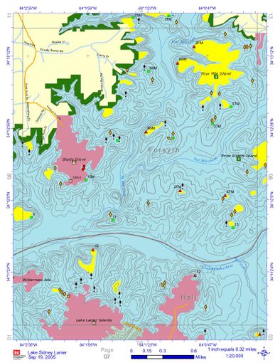
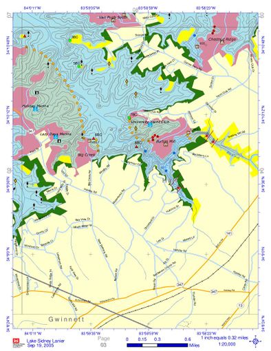
gallery | The maps are from the [https://www.sam.usace.army.mil/Portals/46/docs/recreation/OP-SL/Maps/LakeLanierMapBook%202005-09-19.pdf Lake Lanier Map Book]. They show geographic contours, and unlike many such maps, include contours under water level. This is especially helpful when the lake is at lower levels as obstructions appear in what might otherwise appear to be very open water. Click on a map to see a larger version. Captions contain links to places within the map. | ||
* [https://windsportatlanta.com/wiki/File:Lanier-contour.jpg Combined contour map of the major windsurfing and sailing areas for Lake Lanier] | |||
* [https://windsportatlanta.com/wiki/File:LakeLanierMapBook_2005-09-19.pdf Complete contour map book for Lake Lanier for windsurfing, kiting, sailing and other activities] | |||
<gallery widths=400px heights=510px perrow=2 caption="Lake Lanier Contour Maps" showfilename=1 > | |||
File:Keith's_Bridge.jpg|[[Keith's Bridge Park]] | |||
File:MtView_Sunrise_Old_Federal.jpg|[[Mountain View Park]] to [[Sunrise Cove]] to [[Old Federal Park]] | |||
File:Vanns_Tavern.jpg|[[Vann's Tavern Park|Vann's Tavern]] | |||
File:LLSC.jpg|[[Lake_Lanier_Sailing_Club_(LLSC) | Lake Lanier Sailing Club]] | |||
File:West of Two Mile.jpg|[[Two Mile Creek Park]] and Westward | |||
File:Van Pugh Aqualand.jpg|[[Van Pugh Park|Van Pugh]] to Aqualand | |||
File:Tidwell.jpg| [[Tidwell Park]] | |||
File:Holiday_VP_South.jpg| [[Van Pugh South Park | Van Pugh South]] to Holiday Harbor | |||
File:West_Bank.jpg| [[West Bank Park]] | |||
</gallery> | |||
[[Category:Windsurfing Sites]] | |||
[[Category:Southeast]] | |||
[[Category:Georgia]] [[Category:Atlanta Area]] [[Category:Lake Lanier]] | |||
[[Category:Maps]] | |||
Latest revision as of 23:56, 9 October 2019
The maps are from the Lake Lanier Map Book. They show geographic contours, and unlike many such maps, include contours under water level. This is especially helpful when the lake is at lower levels as obstructions appear in what might otherwise appear to be very open water. Click on a map to see a larger version. Captions contain links to places within the map.
- Combined contour map of the major windsurfing and sailing areas for Lake Lanier
- Complete contour map book for Lake Lanier for windsurfing, kiting, sailing and other activities
- Lake Lanier Contour Maps
West of Two Mile.jpg Two Mile Creek Park and Westward
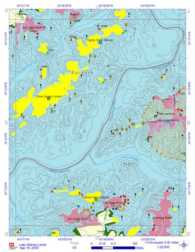
Van Pugh Aqualand.jpg Van Pugh to Aqualand
Holiday VP South.jpg Van Pugh South to Holiday Harbor


